Holy Land Trip of 2009
Turkey
Introduction
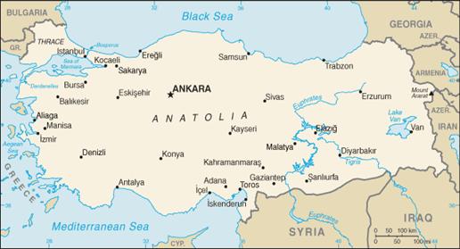 Turkey, officially known as the Republic of Turkey, is a Eurasian country. By far, the majority of the country lies in Asia. In size, Turkey is slightly larger that the State of Texas, and is bordered by eight countries: Bulgaria to the northwest; Greece to the west; Georgia to the northeast; Armenia and Azerbaijan and Iran to the east; and Iraq and Syria to the southeast. The Mediterranean Sea is to the south; the Aegean Sea to the west and the Black Sea to the north. Separating the European from the Asian parts of the country are, starting from the north; Bosporus, the Sea of Marmara, and the Dardanelles. The highest point in Turkey is Mount Ararat, near its eastern border, with an altitude of 16,946 feet.
Turkey is one of the most fascinating countries in the world, whose history is filled with Hittites, Persians, Greeks, Romans, Seljuks, Crusaders, and Ottomans. The history of this land goes nearly back to the beginning of human history. At about 2,000 BC, the Hittites ruled much of the central and eastern parts of present-day Turkey, extending into northern Syria and northwestern Mesopotamia. After the 13th century BC, the kingdom fragmented into a number of city-states. It is an interesting fact that when Pharaoh Tutankhamen died at a young age, his widow requested the king of the Hittites send one of his sons to her so that she might have a worthy match as a husband. The king complied, but his son was murdered on the way.
Between the 12th century BC and the 6th century BC, the land was primarily ruled by Greek factions. These centuries in Turkey’s history are sometime referred to as the Turkish dark ages, because little is known about Anatolia during that time.
In the 6th century we have the invasion of the Persians into this area, in the person of King Cyrus, the same king that conquered the Babylonians on the night of Belshazzar’s feast (Daniel 5:30), allowing the exiled people of Judah to return home at the end of Israel’s 70 years of captivity. In the Bible, Cyrus is one of seven people who were named by God prior to their birth. God revealed through the prophet Isaiah (44:28), 150 years before his birth, that Cyrus would be the one to allow a rebuilding of the temple in Jerusalem.
In 129 BC, the Romans established the Roman province of Asia, which included most of the territory of the former Pergamene kingdom. Eventually all of Asia Minor came under Roman control and various provinces were created by the Romans, including Asia, Bithynia, Pontus, Galatia, Lycia, Pamphylia, Cilicia and Cappadocia. The Romans enlarged and enhanced many cities throughout Asia Minor, such as Ephesus, Pergamum, Antioch, Sardis, Miletus and Phaselis.
During the Roman imperial period, Christianity came to Asia Minor. The Apostle Paul traveled extensively throughout Asia Minor, establishing many churches in a number of locations. The Apostle John addressed his Apocalypse (Revelation) to seven churches in the western part of Asia Minor. Despite much persecution, the church flourished. I will say more about their ministries as we get to each city.
A number of church councils occurred in what today is called Turkey. Two major councils were: The Council of Nicaea (modern Iznik) in 325, and the Council of Ephesus in 431.
Modern Turkey was established in 1923 by Mustafa Kemal Atatürk. He establish a more democratic form of government. He is highly revered in the country to this day and photographs of him are seen everywhere as you drive in the country.
Here are some interesting facts about the country of Turkey.
• Population – 71,892,808 – July 2008
• Median age – 29.0 years
• Life expectancy at birth – male = 70.67, female 75.73 (2008 estimate)
• Ethnic groups – Turkish 80%; Kurdish 20%
• Religion – 99.8% Muslim; 0.2% other, mostly Christian
• Land use – 29.81% arable land
• Money – Liras (Currently 1.67 Liras per US Dollar)
• Language – Turkish
Here are a few hints with regard to the Turkish language. In print, a number of their letters have added characteristics. Let me give you a few that I have learned from earlier visits. They have 29 letters, and do not have the equivalent of our Q, W or X. Of these 29 letters, 8 are vowels (A, E, I, İ, O, Ö, U, Ü); the 21 others are consonants. Look at the variations in the vowels first.
The ‘I’ in most middle eastern languages has the sound of a long-E in English, like the “I” in Elite.
The ‘İ’ with a dot over it (whether a capital or lower case) is pronounced like the “I” in HIT.
The ‘O’ is pronounced like the “o” in our NO.
The ‘Ö’ is pronounced like the “e” in HER.
The ‘U’ is pronounced like the “oo” in BOOT.
The ‘Ü’ has no English equivalent, but is pronounced like the German ü in über.
For variations in the consonants, note the following
ğ This letter is silent – no sound. The curve above the Ğ is called a “breve.” In the Cappadocia area, we will be near a city named Niğde, pronounced “Nee-Day.”
ş This ‘s’ has a “cedilla” attached, and is pronounced as “sh” as it is in sugar.
ç This ‘c’ also has a cedilla attached and is pronounced as a “ch” as in cello.
 For those familiar with the software program, Google-Earth, as I write about each of the places we will visit, I will give the coordinates so you can see a satellite view of that place if I can locate it. Near the name of each place you will see the Google Earth icon.
 Istanbul
Istanbul is the only city in the world that crosses the boundaries of two continents – The European and Asian continents. It really does sit on both sides of the Bosporus.
Istanbul’s history does not go back as far as most of the ancient sites we will visit on this trip. Its history prior to 100 B.C. is very scarce, although it is known that people lived there. But it wasn’t a major city until the 1st century B.C.. It was during that first century before Christ, that this city became part of the Roman Empire. And in 306 AD, Emperor Constantine the Great made this city, then called Byzantium, the capital of the eastern Roman Empire and changed its name to Constantinople, and in the 15th century, it was changed to Istanbul.
As one drives around Istanbul, you will see parts of the ancient Byzantine wall that once circled the city. And it was also the only place in Turkey where we will probably run into traffic jams. There are very few cars on the highways outside the large cities, which is probably because gasoline prices are quite high, costing between $8.00 (unleaded) and $10.00 (diesel) per gallon when converting from Lira per Liters.

Istanbul is Turkey’s largest city, with a population in excess of 11 million, as of 2007, with a population density of 2,742 people per square mile.
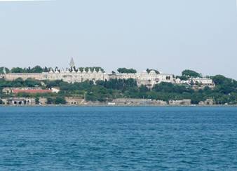
Topkapi Palace (Day 3)
 Google-Earth coordinates: 41º00’45.60”N, 28º59’02.52”E
The palace was built atop a high point overlooking the Sea of Marmara and the Bosporus, and was a setting for state occasions and royal entertainments and is a major tourist attraction today. The complex has been expanded over the centuries, with many renovations such as after the 1509 earthquake and 1665 fire.
After the end of the Ottoman Empire in 1921, Topkapi Palace was transformed by government decree to be a Museum in 1924, after Atatürk became president.
Hagia Sophia (Day 3)
 Google-Earth coordinates: 41º00’30.63”N, 28º58’47.85”E

The Hagia Sophia is one of the most extraordinary buildings in the history of architecture. Hagia means “divine,” “holy,” or “sacred,” and Sophia means “wisdom.” It was for centuries considered the mother church of all Eastern Orthodox churches.
Constantius II, the son of Constantine the Great, had this church built. The church was first completed in 360 AD.
Unlike most of the early Christian churches, this church was not named for a saint. At first it was given the name “Megala Ekklesia,” meaning, “The Great Church”, because it was the largest at that time. Later it became known as Holy Wisdom. In Latin, it is Sancta Sophia, Hagia Sophia in Greek, and Aya Sofya in Turkish.
The dome of this church is 105 feet in diameter and stand 184 feet high. Through the centuries, earthquakes have damaged the church, but not in a major way. In the sixth century, after a fire had burned most of the church, the Roman emperor Justinian I, being a strong Christian believer, wanted this church rebuilt and used as a means for enlarging the scope of Christianity. The church served as the heart of the empire, and the coronation of all Byzantine emperors occurred here.
When the Turks conquered Istanbul in 1453, one of the first things they did was to convert this church into a mosque. That is why the church today has four minarets, additions added later. Mustafa Kemal Atatürk, believed the country should try to remain diverse, so in the 1920’s, he stopped the Hagia Sophia from being a mosque, and in 1940 it was reopened as a museum. The frescos and the mosaics are outstanding.
Chora Church (Day 3)
 Google-Earth Coordinates: 41º01’52.38”N, 28º56’20.67’E
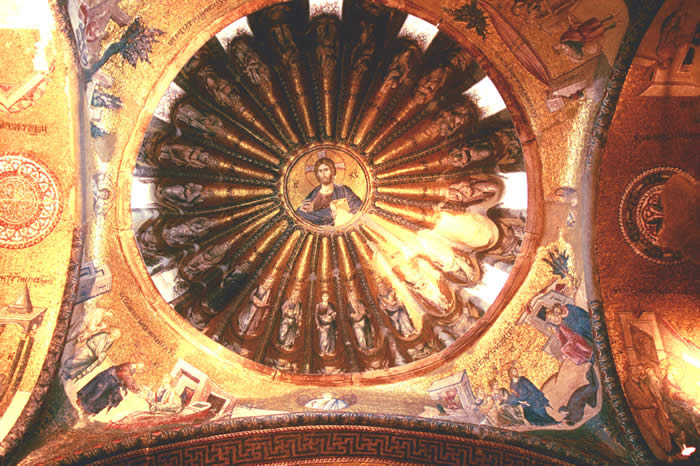
The Chora Church has no biblical significance, but it is an excellent and beautiful example of a Byzantine church. The church was made into a museum in 1948. Inside, you will find an amazing array of mosaics and frescoes, of which there is a total of 52, most of them in very good condition. You will be struck with the radiant colors and vivid figures.
When it was originally built in the 5th century, it was located outside the walls of Constantinople. Over the centuries, because of both wars and earthquakes, the church has been damaged and restored many times. Today, much of what is seen on the site in from the 11th century. The church's full name was the Church of the Holy Saviour in the Country (Greek - hē Ekklēsia tou Hagiou Sōtēros en tē Chōra). The last part of that name, Chora, referring to its location (in the country) originally outside of the walls, became the shortened name of the church.
The church consists of the nave, the inner narthex, outer narthex and the paracclesion. The domes of the inner narthex and the paracclesion are lower than the main dome and are only seen from the rear of the church.
Cappadocia (Day 4)
 Cappadocia is an extensive inland district in eastern Asia Minor. In many ways, this area is unlike any other in the world, both in is above ground landscapes and its many underground cities. The unique pointed landscape are sometimes called “Fairy Chimneys.” During most of the 2nd millennium before Christ, much of this area was under the influence of the Hittites, The center of Cappadocia is only 80 miles due south from the Hittite capital city of Hattusa. The Hittites are mentioned in the Old Testament 21 times, from Genesis to Nehemiah.
The altitude of the area ranges from 3,000 to 5,000 feet.
The earliest record of Cappadocia does not precede the 6th century B.C., during the time of the Persian invasion, under King Cyrus.
Cappadocia is mentioned in the Bible only twice, with no activity mentioned. In Acts 2, there are Cappadocians, among other nationalities, that witnessed the outpouring of the Holy Spirit on the Day of Pentecost (Acts 2:9). And when Peter addresses his first epistle, he says (in 1 Peter 1:1), “To the pilgrims of the dispersion in Pontus, Galatia, Cappadocia, Asia and Bithynia,…” In the Jewish Mishna, this area is linked to the descendants of Meshech, the son of Japheth. Flavius Josephus also makes that link, saying those that once were called “Mosoch” are now called Cappadocians.
We will be visiting several sites in the region of Cappadocia – primarily, Kaymakli, Goreme Valley and Avanos (See map on following page). There are at more than 40 underground cities in the Cappadocia region.
To give some perspective on the map below, the distance from Avanos to Kaymakli is only 18 miles. And Nevşehir is the capital city of Cappadocia.

Kaymakli (Day 4)
 Google-Earth Coordinates: 38º27’36”N, 38º45’12”E
Kaymakli lies at an altitude of just under 5,000 feet. The name Kaymakli means, “cream made of milk.”
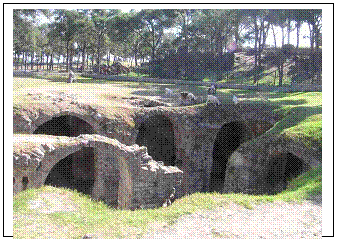
Archaeological records show the first inhabitants of Kaymakli were probably the Hittites. The underground city was discovered and opened to tourists in 1964. Unlike some underground cities, Kaymakli is burrowed into a large hill, called the Citadel. People of Kaymakli (Enegup in Greek) village have constructed their houses around nearly one hundred tunnels of the underground city. The inhabitants of the region still use the most convenient places in the tunnels as cellars, storage areas and stables, which they access through their courtyards. Kaymakli Under-ground City has low, narrow and sloping passages. As can be seen in the diagram at right, the city had anumber of layers (Kaymakli has 8 layers) and tourist are able to visit four of them. Like cities above ground, those underground had a system of streets. All such cities are built around a series of ventilation shafts. Water needed by the inhabitants is found by burrowing the ventilation shafts deeper until the water level is found.
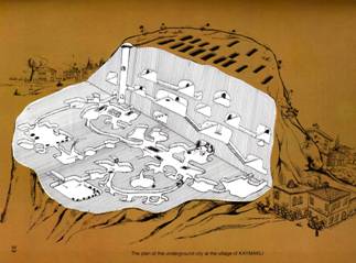
Even though the whole city has not been completely opened, and since only 8 floors have been uncovered, it is certain that Kaymakli is one of the largest underground settlements in the region. The number of the storage rooms in such a small area supports the idea that a great number of people resided here. Archeologists think that, this can be up to 5000 people.
During the Christian era, these underground cities became important places of refuge for thousands ofChristians. During the 2nd and 3rd centuries, they could escape persecution by Roman soldiers. Churches were also created in these cities when the Christians inhabited them. These churches often display a number of well-preserved frescoes.

As can be seen in the photo to the right, at strategic places throughout the city were placed circular stones that could be rolled across the opening if it was necessary to stop intruders. And they could be opened only from the inside. Some of these cities were very large, like the city of Derinkuyu, which had as many as 10,000 residents, having a minimum of 12 layers, going underground up to 270 feet. In the larger cities, there would be 2 or 3 or more churches.
Göreme (Day 5)
 Google-Earth Coordinates: 38° 39' 58" N 34° 50' 33" E
The current Google-Earth view is cloudy, making it difficult to get a good closeup view. But you will find many photos submitted by previous travelers to this site. The Google-Earth coordinates for the Göreme Open Air Museum is as follows:

 Google-Earth Coordinates: 38° 38' 19.64"N 34° 50' 42.81"E
Göreme is about the first name one thinks of when Cappadocia is mentioned, since it was the first place that became widely known for its marvelous “fairy chimneys” and other rock formations. The valley in which the city of Göreme lies has an altitude of approximately 3,400 feet.
Göreme, was earlier called Göremi, which was supposed to mean “you cannot see.” Later it was changed to Korama and then finally into Göreme. People still live in the rock houses or use them as storerooms today. The village of Göreme does not only have rock houses, but also rock restaurants and rock hotels which visitors find amazing.
There are over 400 churches in the Cappadocia area. There are at least 10 cave churches in Göreme. The Turkish word for church is KILISE, if it has a masculine name. If the church is named after a female, the word for church changes to KILISESI. Photo to the left is one church in Göreme. At right is the Elmali Kilise
Avanos (Day 5)
 Google-Earth Coordinates: 38° 43' 11.89" N 34° 50' 43.19" E
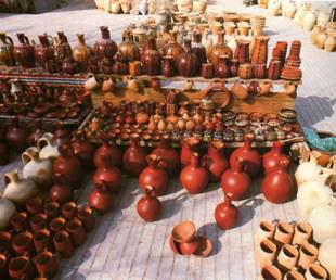
Avanos, a city of approximately 12,000, is located on the banks of the Red River (Kizilirmak in Turkish), which gets its name from the clay that the river deposits. On the map on page 6, you will see the Kizilirmak River running through Avanos flowing east to west, and is the longest river in Turkey.
The clay deposited there has for centuries provided the city residents with the resources for its pottery industry. And to this day, Avanos is dominated by this industry, although tourism has become a large part of its economy. You will see many pottery shops along the streets. Archaeologists have discovered that the pottery business in this area goes back to at least the time of the Hittites.
In 1972, they discovered an underground city 9 miles northeast of Avanos. The city’s name was Özkonak and is built on the slopes of Mt. Idis. It is interesting how this discovery was made. A farmer, named Latif Acar, went searching for where water for his crop irrigation was disappearing. He first found an underground room which, when later excavated, revealed a whole city which could have housed an incredible 60,000 people for up to three months. A total of 10 floors were discovered, to a depth 40 meters, although now only four are open.
Pisidian Antioch (Day 6)

 Google-Earth Coordinates: 38° 18' 15.00" N 31° 11' 25.19" E
You can compare what is visible on Google-Earth with the layout diagram to the right. The altitude at Antioch is about 3,800 feet and is located one mile north of the modern city of Yalvaç.
Several cities in the ancient world were called Antioch, named for various members of the Seleucid Dynasty who bore the name Antiochus. This city was founded either by Antiochus I or Antiochus II, but it only achieved prominence after its refounding as a Roman colony in 25 B.C.
Although overshadowed in the new Testament by Syrian Antioch (on the Orontes River), Pisidian Antioch was an important city during Hellenistic and Roman times.
In the city layout at right, there are a couple of things worth noting. During the 3rd or 4th centuries, the theater was enlarged, and in doing so, it intersected with Decumanus Maximus. So, in the renovation, a tunnel approximately 61 feet long, was constructed through part of the seating area.
Also, outside the city walls to the north was an aqueduct that brought water to the city from springs some six miles away in the hills. You can still see the remains of several arches of the aqueduct.
There were 16 different cities of antiquity named Antioch. Thus the reason for the additional descriptor, such as Pisidian Antioch, Syrian Antioch, etc.
Archaeological excavations have uncovered the remains of a thriving city, complete with theater, baths, temples, stadium, nymphaeum, paved streets, and aqueduct.
There was a large temple dedicated to Caesar Augustus, on which are inscribed a list of his accomplishments. Antioch of Pisidia was the most Romanized city of central Anatolia, and 3,000 veteran soldiers were brought here to settle in this area. Antioch was primarily a gentile city, with a large Jewish community. When the early church was persecuted in Jerusalem, many left and went as far as Antioch.
Biblical Significance
On the First Mission Journey, Paul and Barnabas leave the island of Cyprus and enter the city of Perga (Today Perge) and proceeded to Antioch. From Perga they would have followed the Via Sebaste (Sebastian Way), one of the Roman roads built by Caesar Augustus in 6 B.C. Via Sebaste ran north from Perga to Antioch, then east to Iconium and Lystra, two of the cities where Paul and Barnabas ministered after leaving Antioch. In Acts 13:14, Paul and Barnabas entered the synagogue of Antioch on the Sabbath, where the rulers of the synagogue asked them if they had words of exhortation for the people that day. Their message was so well received that on the following sabbath “almost the entire city gathered” to hear them (13:44). They were able to make a number of converts to Christianity, and we are told “the Word of the Lord spread throughout the region” (`13:49). But their popularity created jealousy on the part of some of the Jews, who stirred up persecution 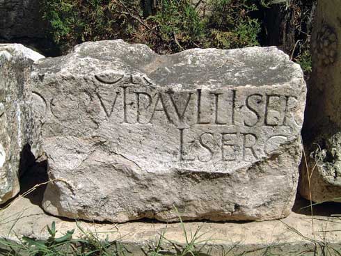 against Paul and Barnabas, and drove them out of the region (13:50). Paul and Barnabas then travel to Iconium, Lystra and Derbe. On their return to Perga, they pass again through Antioch and encourage the new believers (14:21-22).
An inscription has been discovered at Antioch of Pisidia that appears to be linked to the Proconsul of Cyprus. (See image at right). The last place Paul and Barnabas (and John Mark) visited on the Island of Cyprus was the city of Paphos. They met with the proconsul, Sergius Paulus, who was converted to Christianity (Acts 13:4-12) while they were in that city. That meeting with the proconsul might have influenced Paul and Barnabas to immediately go to Antioch of Pisidia. The inscription discovered in Antioch in 1912 mentions the name “L Sergius Paullus the younger.” Sergius Paulus was not an uncommon names, so connecting it the Sergius Paullus on Cyprus isn’t automatic. We do know from historical records that Sergius Paulus may have had relatives who lived in Antioch of Pisidia at that time, and it is also conjectured that this city may have been the home town of the proconsul.

In describing Paul’s second missionary journey, Luke says Paul revisits several churches that had been established in southern Asia Minor. Although Antioch is not mentioned, Acts does say that after visiting Derbe and Lystra, Paul “went through the region of Phrygia and Galatia” (16:16). Perhaps that implies he passed through Antioch.
At left is a picture of the ruins of the Church of St. Paul. According to W.M. Ramsay (1851-1939), excavations have revealed a 1st century building underneath the church, which has been identified as a synagogue. Even more recently, a mosaic floor has been found with Psalm 42:4 inscribed on it. This is believed to be the synagogue in which Paul and Barnabas would have ministered.
Antalya (Day 7)
 Google-Earth Coordinates: 36° 53' 15.61" N 30° 41' 44.91" E
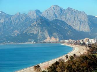 Antalya is a large port city with a 2007 population of 775,157 people, the eleventh largest in modern Turkey. It is the capital of the Antalya province (ancient Pamphylia). As can be seen in the photo to the left, Antalya is surrounded by Taurus Mountains.
The city enjoys 300 plus days of sunshine and the average high and low temperatures for when we will be there is 83º and 63º. And the temperature of the Mediterranean water never goes below 59º (70º in the summer). Because of its very mild and sunny climate, even in winter, this is a popular vacation destination for not only the Turkish people but of all Europe.
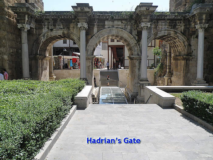
It is not known when the city was first inhabited. Attalos II, king of Pergamum, was believed to have founded the city around 150 B.C., naming it Attalia and selecting it as the base for his naval fleet. During the second century, Emperor Hadrian conferred the status of colony on the city and visited Attalia in 130. The Hadrian Gate (photo at right) was built to commemorate this visit.
In 133 B.C., King Attalos III bequeathed all of his possessions to the Roman Empire, including this city. More will be said about that decision when discussing the city of Pergamum.
When Paul and Barnabas were at the end of their first missionary journey, they left Perga and went to Attalia. From Attalia they left by ship and returned Syrian Antioch (Acts 14:25-26). We are given no information as to spending any time in this city, and this is the only place in the Bible where Attalia is mentioned. The modern Yacht Harbor is located on the site of the ancient harbor of Attalia, from which Paul and Barnabas would have sailed when they left Asia Minor. Around the harbor are portions of the ancient city walls and towers.
Places to visit: The Antalya Museum won the European Museum of the Year in 1988. The exhibits are attractively displayed and are labeled in English as well as Turkish. The ruins of the ancient city of Side are numerous and would be worth a visit. Side is located 40 miles east of Antalya.
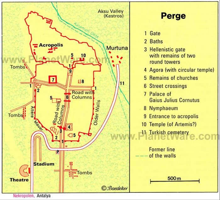 Perge (Day 7)
 Google-Earth Coordinates: 36° 57' 35.96" N 30° 51' 11.00" E
Perge (Perga in the Bible) is located about 9 miles northeast of Antalya, and was the capital city of the ancient province of Pamphylia. Pamphylia is bounded on the north by Pisidia and on the south by the Mediterranean Sea. There must have been a contingent of Jews in the province, for we find them among the nationalities mentioned in the Day of Pentecost (Acts 2:10).
Perge lies in the plains of Pamphylia, eight miles up the Cestrus River (Modern name = Aksu R.). In ancient times, the Cestrus River was navigable and Perge had a port on the river. Today, because of silting over the centuries, the river is not navigable.
Perga was founded by Greek settlers in the 13th century B.C. under the leadership of Calchas and Mopsus, both ancient seers. When Alexander the Great came through this area in 333 B.C. Perga offered no resistence. In the third century, Perga was part of the Seleucid Empire and later became part of the Pergamene Empire. Though the city was never a stronghold of Christianity, it was the bishopric of Western Pamphylia, and several of the early Christians were martyred there. During the 8th century under Byzantine rule the city declined; in 1084 Attalia became the more important metropolis, and Perga rapidly fell to decay.
One of the more famous residents of Perga was the mathematician Apollonius (262-190 B.C.), who was a student of Archimedes.
 When you approach to the city you first see the ruins of the ancient theater, its stage has marble reliefs depicting the life of the Greek god, Dionysus. Then you can view the stadium, which has a "U" shape with the capacity of 12,000 people. After the parking area, there are the remains of the first church built in Perge and a square agora (market place) which has dimensions of 250x250 feet and surrounded by Corinthian style column capitals, where in the middle of it there round temple.
Perga is mentioned twice in the Bible, both in connection with Paul’s first missionary journey. In Acts 13:13, we are told that Paul, Barnabas and John Mark leave Paphos in Cyprus, where Sergius Paulus became a Christian, and sailed to Perga. The fact that Attalia, a port city, is not mentioned at this time possibly gives added credence to the fact that the Cestrus River was navigable. It was while they were at Perga that John Mark, for some unexplained reason, decides to return to Jerusalem. We are told that John Mark was a cousin of Barnabas (Colossians 4:10).
After visiting several cities in Asia Minor, including Antioch, Iconium, Lystra, and Derbe, Paul and Barnabas return to Perga. Paul was not treated well in these cities, one time being left for dead (Acts 14:19). Later, when Paul wrote to Timothy, he mentions the persecution at Antioch, Iconium and Lystra and how “out of them all the Lord delivered me.” (2 Timothy 3:11). They escape and return to Perga (Acts 14:25). This time, they remain in Perga long enough to preach the gospel. Rather than take a boat down the river, they walk to Attalia (Antalya), from where they sailed back to Syrian Antioch.
Aspendos (Day 7)
 Google-Earth Coordinates: 36° 56' 24" N 31° 10' 10" E
Aspendos is located 17 miles straight east of Perge and about eight miles inland.
Aspendos was founded by Greeks around 1000 B.C. At that time the Eurymedon River was navigable as far as Aspendus, and the city derived great wealth from a trade in salt, oil, and wool.
In 333 B.C. Aspendus paid Alexander the Great a levy to avoid being garrisoned, but it ignored its agreements with him and later was occupied. In 190 B.C. the city surrendered to the Romans, who later pillaged it of its artistic treasures. Toward the end of the Roman period the city began a decline that continued throughout Byzantine times.
From Cicero's presentation of the case before the Roman senate, we know that in 79 B.C. Gaius Verres, the questor of Cilicia, pillaged Aspendos just as he had done to Perge. Verres, right in front of the citizens, took statues from the temples and squares and had them loaded into carts. He even had Aspendos famous statue of a harpist set up in his own home.

Aspendos is famous for what is probably the best preserved of all ancient theaters, having a capacity of 15,000 people and is still used today. The theatre at Aspendos is also famous for its magnificent acoustics. Even the slightest sound made at the centre of the orchestra can be easily heard as far as the uppermost galleries. Anatolia's patricians, who lived in the midst of a rich cultural heritage, created stories connected with the cities and monuments around them.
One of these tales which has been passed down from generation to generation is about Aspendos' theatre. The king of Aspendos proclaimed that he would hold a contest to see what man could render the greatest service to the city; the winner would marry the king's daughter. Hearing this, the artisans of the city began to work at high speed. At last, when the day of the decision came and the king had examined all their efforts one by one, he designated two candidates. The first of them had succeeded in setting up a system that enabled water to be brought to the city from great distances via aqueducts. The second built the theatre. Just as the king was on the point of deciding in favour of the first candidate, he was asked to have one more look at the theatre. While he was wandering about in the upper galleries, a deep voice from an unknown source cried out saying again and again, "The king's daughter must be given to me." In astonishment the king looked around for the owner of the voice but could find no one. It was, of course, the architect himself, proud of the acoustical masterpiece he had created, who was speaking in a low voice from the stage. In the end, it was the architect who won the beautiful girl and the wedding ceremony took place in the theatre.
Laodicea (Day 8)

 Google-Earth Coordinates: 37° 50' 10" N 29° 06' 32" E
Today we travel about 130 miles by road to Laodicea. The locals today call it Loudikya. The town was originally called Diospolis (city of Zeus), and after that called Rhoas.
Laodicea is located on the Lycus River near two other biblical cities. Colossae is 10 miles to the southeast and Hierapolis is 6 miles north. This area was part of the region of Phrygia, although it was sometimes considered a part of Lydia or Caria. Laodicea was located at the juncture of two main roads – one that ran from the Aegean coast near Ephesus through the Meander River valley and on to the Euphrates. The other ran from Pergamum to Sardis, through Laodicea, and then to Perga and Attalia (Modern Antalya). These roads brought Laodicea much commerce.
Antiochus II founded the city in the middle of the 3rd century B.C and named it for his wife, Laodice. By the time the Romans took over this part of the world, Laodicea was already known as a banking center. The textile and the wool trade was a cash cow for the Laodiceans. And there was even a medical school that had developed ear and eye ointment. Laodicea was quite possibly the wealthiest city in the world at this time. When a massive earthquake leveled many cities in western Asia Minor in A.D. 17, the city fathers refused help from Rome to rebuild, but rebuilt the city with their own funds.
Although this was once a thriving city, most of the ruins of the city remain underground awaiting excavation, thus you will not usually find many tourists at this site. On an earlier visit to this site, a shepherd was grazing his sheep next to the ruins of the theater.
The city of Laodicea is mentioned in the Bible in only two books – Colossians and Revelation. The three churches in this area most likely were not started by Paul. Those three cities are Laodicea, Colossae, and Hierapolis, and they were probably started by Epaphras, who was a resident of Colossae. And Paul honors him and gave him his support.
Colossians 1:3-7 NKJV
3 We give thanks to the God and Father of our Lord Jesus Christ, praying always for you,
4 since we heard of your faith in Christ Jesus and of your love for all the saints;
5 because of the hope which is laid up for you in heaven, of which you heard before in the word of the truth of the gospel,
6 which has come to you, as it has also in all the world, and is bringing forth fruit, as it is also among you since the day you heard and knew the grace of God in truth;
7 as you also learned from Epaphras, our dear fellow servant, who is a faithful minister of Christ on your behalf,
This tells me that Paul and his band of assistants heard of the faith these saints had. He wasn’t the one to bring them to the Lord. He says they had learned from Epaphras, who was a faithful minister of Christ. In the latter years of Paul’s life, Epaphras either accompanies him to Rome, or goes to visit him there. Paul writes his 3 letters to the Ephesians, Colossians and Philippians while in prison in Rome.
Colossians 4:12-13 NKJV
12 Epaphras, who is one of you, a bondservant of Christ, greets you, always laboring fervently for you in prayers, that you may stand perfect and complete in all the will of God.
13 For I bear him witness that he has a great zeal for you, and those who are in Laodicea, and those in Hierapolis.
From these passages, it is believed by most Bible scholars that Epaphras probably began all three of these churches. We are not told where Epaphras first met the apostle Paul.
 This is the last of the 7 churches mentioned in Revelation 2 & 3. The letter courier has made his rounds and has reached his final destination. The city of Laodicea was located roughly 45 miles south of Philadelphia. This letter to the Laodicean church contains our Lord’s harshest appraisal of all the 7 churches. Unlike most, if not all the others, He offers no commendations to this church.
In Laodicea, you might see the ruins of aqueducts and pipes. These become images of the message given by Jesus through the apostle John in the Book of Revelation. Laodicea had a problem – it lacked an adequate water supply source. So they constructed aqueducts to bring water from two sources. There were hot mineral springs about 6 miles north in Hierapolis. These waters were used for their healing properties. There were also icy cold waters from springs 7-8 miles to the southeast in Colossae.
The problem was this – the mineral hot spring water cooled in its journey of 6 miles, and by the time it arrived most of its valuable minerals had seeped out. The icy waters went through a similar fate over their 7-8 miles journey. The cold water warmed up as it passed through the aqueduct and also reached the fountains in a lukewarm condition. So when a visitor came to the city having traveled the hot plains, they would be seen taking a big gulp of water only to spit it out in disgust. So this congregation would know precisely the meaning of Christ when He says:
15 I know your works, that you are neither cold nor hot. I wish you were either cold or hot.
16 So then, because you are lukewarm, and neither cold nor hot, I will vomit you out of My mouth.
I will have more to say about this church during the trip.
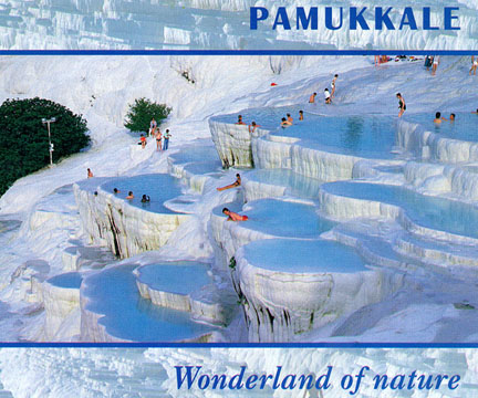
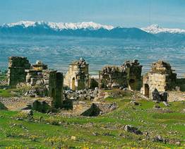
Hierapolis (Pamukkale) (Day 8)
 Google-Earth Coordinates: 37° 55' 37" N 29° 07' 41" E

When we were in Cappadocia, we witnessed some very unique natural landscapes. Pumakkale, for different reasons, also provides very unique geologic formations. Before you arrive at Pamukkale (Heirapolis), you will see the side of the hills completely covered with calcified pools created over thousands of years from many hot springs.
The calcium oxide-rich waters flowing down the slopes have built deposits of white travertine. For millennia, these waters have been thought to have healing powers. As the water comes from the springs beneath, they remain at a fairly constant 35ºC/102ºF. When the water loses its carbon dioxide, it leaves limestone deposits. These can be of various colors and shapes, and form an array of terraces with pools. Pamukkale, which means “cotton castle” in Turkish, takes its name from these formations. Because of these hot springs, there are many tourists here, unlike the few at Laodicea. Because of their size, you can see these mineral-laden cliffs from Laodicea.
Pamukkale is located at the bottom of the valley where the Lycus and Maeander Rivers come together. The ruins of the ancient city of Hierapolis are above the calcified cliffs, some 150 to 300 feet above the valley floor.
 Unlike most other areas of centraland southern Anatolia, there is no indication of a presence of either the Hittites or the Persians. Most sources agree the city was founded by Eumenes II, King of Pergamum.
The name Hierapolis means “holy city.” It was an ancient center for pagan cults until it was transformed into a Christian center. Colossians 4:13 tells us that this church, along with those in Laodicea and Colossae, had done a great work for the Lord. The churches in these three cities in this area most likely were not started by Paul. They were probably started by Epaphras. And in Colossians, chapter 1, Paul honors him and gave him his support.
 When you enter Hierapolis from the north, you will see a major necropolis with sarcophagi on both sides of the modern road for a distance of about two miles. There are over 1,400 grave sites around the city, with the necropolis on the north being the largest. This is the largest graveyard in all Anatolia. Some of these sarcophagi date to the time of the apostle Paul. Over the centuries, the tombs have been invaded by robbers
Those traveling from Sardis or Philadelphia from the north would travel past the northern necropolis to the arched Gate of Domitian into the city. Beyond the gate, moving south along the colonnaded street known as Frontinus Street, to the left would be the 300 feet by 150 feet agora (marketplace). Frontinus Street was 13 meters (42 feet) wide, between the row of columns and paved with huge blocks of limestone, and in ancient times was nearly a mile in length. Since Hierapolis was a luxury resort town, it was richly adorned with magnificent sculptures.
There is also a very strong tradition that the apostle Philip lived in Hierapolis with his daughters and was martyred here in about 80 A.D. Polycrates, bishop of Ephesus during the second century, states in his writings that Philip was buried in Hierapolis. It takes a 10 minute walk up the hill to the ruins of Philip’s Martyrium. The building was octagonal, and about 66 feet across. It was covered originally by a wood dome, covered with lead. Most of what remains are the 8 large corner pillars, because in the late 5th or early 6th centuries a fire destroyed the rest of the martyrium. There has been much discussion over the centuries as to which Philip is honored by this martyrium – whether it is the apostle Philip (one of the Twelve) or Philip the evangelist (one of the seven chosen in Acts 6). Most sources believe it was Philip the apostle.
Sardis (Day 9)
 Google-Earth Coordinates for Temple of Artemis: 38° 28' 45" N 28° 01' 55" E
Google-Earth Coordinates for the Acropolis: 38° 28' 33" N 28° 02' 39" E
Google-Earth Coordinates for Gymnasium & Synagogue: 38° 229' 19" N 28° 02' 26" E
The top two coordinates are fairly accurate, but neither the Temple of Artemis or the Acropolis is distinguishable on Google-Earth. The coordinates for the gymnasium and synagogue are accurate and visible.
 Sardis (sometimes spelled Sardes), modern Sart, is in the Manisa province of Turkey. The name Sardis is that of the stone, sardius (Greek: sardinos) as mentioned in Revelation 4:3, or called Carnelian is some translations. The semi-precious stone is orange-brown but reflects deep red when light is passed through it.
In ancient times Sardis was the capital of the Lydian Empire, and an important city during the time of Persian control. Under the Roman Empire, it was the seat of the proconsul. Sardis is 30 miles southeast of Thyatira and 45 miles east of Izmir (Smyrna). At the time of the apostle John, its population is estimated at 120,000.
Sardis is located in the middle of the Hermus Valley, at the foot of Mount Tmolus, on which was located the citadel or acropolis, some 1,100 feet above the valley. Evidence has been unearthed showing this city to be one of the oldest in Asia Minor.
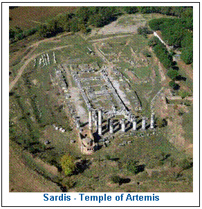
 The Temple of Artemis (at left) was a massive structure, the seventh largest of all Greek temples, twice the size of the Parthenon in Athens. The goddess Artemis is known as Diana by the Romans, the name she is called in the 19th chapter of Acts (in the KJV, NKJV and ASV). We will talk more about Artemis in Ephesus, where an even larger temple to her was built.
In the above picture, you will notice a separate brownish structure at the lower left of the Temple, just below the two highest columns. It is a 4th century church, where Christians worshiped long after the worship of Artemis had ceased.
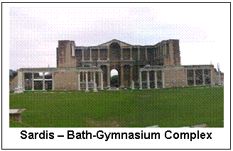
In the valley, we will visit another of the ruins – a gymnasium, which in ancient times would have been in the center of the city. The large bath-gymnasium complex covered five acres.
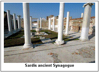
Also, to the left of the above picture, just out of sight is a Jewish Synagogue. It was discovered and unearthed in 1962, and is one of the most significant monuments of diaspora Judaism in Roman Asia Minor. In size it is one of the largest synagogues ever excavated in the ancient world. And to be located in the center of the ancient city speaks to a large Jewish influence in Sardis. It is also important for the more than eighty inscriptions that have been found in its interior. With the exception of six fragments in Hebrew, the inscriptions are in Greek. The area of the synagogue was, at an earlier time, part of the Gymnasium complex. There was a wing on the opposite side of the Gymnasium that, with the area occupied by the synagogue, would have given the Bath-Gymnasium complex a symmetrical structure.
The only place where Sardis is mentioned in the Bible is as the fifth of the seven churches of Revelation, chapters 2 & 3.
Revelation 3:1-6 NKJV
1 "And to the angel of the church in Sardis write, 'These things says He who has the seven Spirits of God and the seven stars: "I know your works, that you have a name that you are alive, but you are dead.
2 Be watchful, and strengthen the things which remain, that are ready to die, for I have not found your works perfect before God.
3 Remember therefore how you have received and heard; hold fast and repent. Therefore if you will not watch, I will come upon you as a thief, and you will not know what hour I will come upon you.
4 You have a few names even in Sardis who have not defiled their garments; and they shall walk with Me in white, for they are worthy.
5 He who overcomes shall be clothed in white garments, and I will not blot out his name from the Book of Life; but I will confess his name before My Father and before His angels.
6 "He who has an ear, let him hear what the Spirit says to the churches."'
Smyrna (Izmir) (Day 9)
 Google-Earth Coordinates for the ancient agora: 38° 25' 08" N 27° 08' 20" E
Google-Earth Coordinates for Mt. Pagus (Acropolis): 38° 24' 50" N 27° 08' 24" E
 The ancient city of Smyrna (Greek: Σμύρνη) is located within the modern city of İzmir, the third largest city in Turkey, with a population of 2.8 million. Located at a central and strategic point on the Aegean coast of Anatolia and aided by its advantageous port conditions, its ease of defense and its good inland connections, Smyrna rose to prominence.
Smyrna is 35 miles north of Ephesus, and, like Sardis, has had a long history going back to nearly 3,000 years before Christ. It’s beautiful landlocked harbor made it difficult for enemies coming by way of the sea. Over its long and eventful history, Smyrna suffered from besieging armies, massacres, earthquakes, fires and plagues. It was captured by the Ionians in the 688 BC, and made into a beautiful city. In 580 BC, the Lydians destroyed the city and again destroyed by the Persians a century later. For the next several centuries, all that existed in the area were 4 or 5 small villages.
In about 335 BC, on the orders of Alexander the Great, Smyrna was rebuilt into a strong well-planned city. This is the genesis of the city that existed at the time of Paul and John. And during the latter half of the first century, the population here was about 100,000.
Because this city had many lives – when it was destroyed and rebuilt many times, the Smyrnaeans were able to relate to the depiction of Christ in this letter, where He says He was “dead and came back to life.” (Rev. 2:8). This city had experienced death and had literally been brought back to life.
Under Lysimachus, one of the generals of Alexander the Great, the city was planned with broad and straight streets that were well-paved. Smyrna became know as the “Flower of Ionia.” It was also called the “Crown of Asia.” This was due to the many porticoes and fortress which encircled the summit of Mount Pagus. Mount Pagus was the acropolis of this ancient city. These shining marble building looked like a crown atop this 600-foot hill.
The city could no longer be contained within its old defense walls and was refounded on Mt. Pagus (Also spelled Pagos), now known as Kadifekale. In 288 B.C. the city became subject to the Pergamene Empire, and in 133 B.C. it became part of the Roman Empire. By the first century B.C. only a small part of the city remained on Mt. Pagus, the greater part lying in the vicinity of the harbor.
 The ancient city of Smyrna, like Ephesus, was a Roman free city. That meant they had earned the right to be self-governing. It had a large library, a stadium, and a large public theater. The Poet Homer, whose birthplace is claimed by several cities, including Smyrna, is said to have written the ILIAD here between 750 and 725 BC. Today, the city is still beautiful. Unlike Ephesus, Smyrna did not have a problem with rivers that silted the harbor. With its excellent harbor, they export crops such as tobacco, grapes, figs, cotton, olives and olive oil.
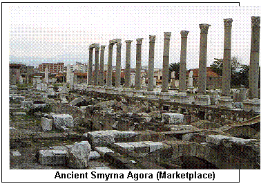
As is typical, when a later city is built on the same location of the earlier city, it inhibits the finding of the ruins of the older civilization. That is true of Smyrna, now Izmir. On the previous page is a photo of the ancient agora. As can be seen by the arches, this agora had two stories, one underground and one above. The picture to the right shows that at one time the lower level of the agora was covered.
Biblical significance:
Smyrna is the second of the seven cities of Revelation to receive a letter from the apostle John.
Christians in Smyrna
We don’t know exactly when the church in Smyrna was founded. I think it is a strong possibility that all the church mentioned in Revelation, excluding Ephesus were started during the time Paul was in Ephesus during his 3rd missionary journey. During this journey, Paul stayed in Ephesus for nearly three years, and we are told he had a Bible school every day in the school of Tyrannus. And then in Acts 19:10, it says:
“And this continued for two years, so that all that dwelt in Asia heard the Word of the Lord Jesus, both Jews and Greeks.”
This church is mentioned only in the Book of Revelation. We know nothing more about it than what we can read in the letter penned by John. I think it is noteworthy that Smyrna (now Izmir) is the only one of the churches that has maintained a continuous unbroken Christian presence since its origin. In fact, it is here where we find one of the last strongholds of Christianity in the entirety of Turkey today.
For the last 1,900+ years, Smyrna has remained a stronghold of Christianity. I have a set of commentaries – called LECTURES ON THE APOCALYPSE – written by Joseph A. Seiss in 1901. At that time, according to Seiss, Smyrna’s population was one-third Christian. But in 1915, a determined and systematic genocide of an ethnic group, the Armenians, who were mostly Christians, a genocide that was instigated by the Ottoman Turks. And the outcry from most other nations did nothing to lessen their atrocities. Smyrna is where the largest contingent of Armenian Christians and other Christians lived. From April 24, 1915, when the genocide started, and on through 1923, 1½ million Armenians were murdered. In 1922, the Ottomans set the Armenian quarters of Smyrna on fire. The fire lasted for weeks, and then sporadically thru June 1923. This destroyed about one third of the city buildings.
Today there are about 15 to 20 active churches here – Protestant, Catholic, Anglican and Eastern Orthodox, at least two of which are evangelical churches, one called the New Birth Church. And there is the First Baptist Church in Izmir.
Revelation 2:8-11 NKJV
8 "And to the angel of the church in Smyrna write, 'These things says the First and the Last, who was dead, and came to life:
9 "I know your works, tribulation, and poverty (but you are rich); and I know the blasphemy of those who say they are Jews and are not, but are a synagogue of Satan.
10 Do not fear any of those things which you are about to suffer. Indeed, the devil is about to throw some of you into prison, that you may be tested, and you will have tribulation ten days. Be faithful until death, and I will give you the crown of life.
11 "He who has an ear, let him hear what the Spirit says to the churches. He who overcomes shall not be hurt by the second death."'
This is the shortest of all the letters – just 4 verses. Yet these four brief verses contain unparalleled words of comfort to this church. Jesus is filled with warm affection. And yet, the Lord’s affection does not say it is going to be an easy road ahead. It is interesting to observe that there is no rebuke to this church.
Of all the seven letters, this one is expressed in the most continuous and unbroken tone of laudation. Out of the seven churches, Christ rebukes 5 of them. The church at Philadelphia is the other church without a rebuke. The interesting thing is that the two churches receiving no rebuke were those who were persecuted the most, though the hardship at Philadelphia was of a different manner. And to Philadelphia, Christ does not promise the crown of life, but asks them to be attentive that no one takes their crown.
Jesus admonished this church to be “faithful unto death.” This church saw much persecution, as is seen in the life of one of its leaders – Polycarp, a disciple of the apostle John. Here is his story.
As the pastor and overseer of the church in Smyrna, his congregation urged him to flee into the countryside in order to escape the persecution of the Romans and others. This was in February, 155 AD. He was hunted down and captured. He did not resist them, but offered them food and drink, and asked for permission to retire for prayer, which he did for two hours. As they traveled into the city, the officer in charge urged him to recant. “What harm can it do to sacrifice to the emperor?” Polycarp refused.
On arrival, he was brought before the proconsul in the amphitheater, who pleaded with him. “Swear by the genius of Caesar… Revile Christ.” Polycarp said: “for 86 years I have served him, and he has done me no wrong; how then can I blaspheme my king who saved me?” The proconsul persisted: “Swear by the genius of Caesar…I have wild beasts; if you will not change your mind, I will throw you to them…” “Call them!” Polycarp replied. “Since you make light of the beasts, I will have you destroyed by fire, unless you change your attitude.” Polycarp strode to the stake and tells them they need not tie him, because God would give him the grace to stay when the fire was lit. He prayed, “O Lord, Almighty God, the Father of your beloved Son Jesus Christ, through whom we have come to know you…I thank you for counting me worthy this day and hour of sharing the cup of Christ among the number of your martyrs.” And he dies that day.
We end day 9 at the Grand Onder Hotel in Kuşadasi (Photo right), the port city near Ephesus. We will stay at the Grand Onder for two nights.
Kuşadasi (Day 9 & 10)
 Google-Earth Coordinates for Kuşadasi: 37° 51' 18" N 27° 15' 27" E
Google-Earth Coordinates for Grand Onder Hotel: 37° 52' 27.73" N 27° 15' 57.84" E
Ephesus (Day 10)
 Google-Earth Coordinates for the ancient agora: 37° 56' 22" N 27° 20' 30" E
Google-Earth Coordinates for the Temple of Artemis: 37° 56' 58.68" N 27° 21' 50.27" E
Google-Earth Coordinates for the Church of St. John 37° 57' 09" N 27° 22' 04" E
 Ephesus (Ancient Greek Ἔφεσος; Turkish Efes) was one of the great ancient Greek cities on the west coast of Anatolia. In ancient times, it was a seaport on the Aegean Sea. They could have used the dredging service of the US Army Corpse of Engineers because after thousands of years of silting by the Cayster River, the ruins of Ephesus are some 5 or 6 miles from the Aegean.
The recordable history for Ephesus begins about 1500 B.C., although archaeological excavations show the surrounding area had people living here back to the 3rd millennium before Christ. I would recommend the book, The Revenge of Ephesus, by Dr. Joseph Fuiten, pastor of Cedar Park Assembly in Bothell, Wa., in which he mentions Hittite records that speak of the “kingdom of Ahavia and the city of Apasas.” It is thought by some historians that the name “Apasas” is the prior name of Ephesus. The city’s history become much more clear about 1000 B.C.
About 650 BC Ephesus was attacked by Cimmerians who razed the city, including the temple of Artemis. A few small Cimmerian artifacts can be seen at the archaeological museum of Ephese. About 560 BC Ephesus was conquered by the Lydians under the mighty king Croesus. He treated the inhabitants with respect, despite ruling harshly, and even became the main contributor to the reconstruction of the temple of Artemis. His signature has been found on the base of one of the columns of the temple (which I have seen on display in the British Museum). Croesus made the populations of the different settlements around Ephesus regroup in the vicinity of the Temple of Artemis, enlarging the city.
Later in the same century, the Lydians under Croesus invaded Persia. The Ionians refused a peace offer from Cyrus the Great, siding with the Lydians instead. After the Persians defeated Croesus the Ionians offered to make peace but Cyrus insisted that they surrender and become part of the empire. They were defeated by the Persian army commander Harpagos in 547 BC. The Persians then incorporated the Greek cities of Asia Minor into the Achaemenid Empire.
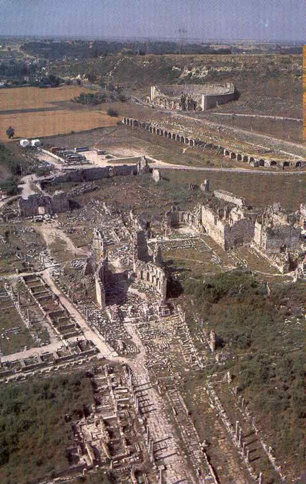
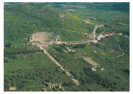 Of all the great cities of the ancient biblical lands, Ephesus is the best preserved. No modern city was built over it. Much of the central area of the city has been uncovered, although, on our last trip there, our guide told us only an estimated 15% of the city has been unearthed. I don’t think anyone who visits this city will ever forget it. In many sites it takes a great amount of imagination to fill in the gaps between ruins. But at Ephesus, only your eyes are needed to appreciate its former beauty and grandeur. At right is an aerial photo of the ancient city of Ephesus.
In the first century when the apostles Paul and John would have been there, the city was the fourth largest in the world, having a population of 250-300,000. The largest three cities, in order, were: Rome, Italy – Alexandria, Egypt, & Antioch, Syria. Ephesus was by far the greatest city in Asia Minor. It claimed as its proud title, “the first and the greatest metropolis of Asia.” On ancient Roman writer called it, Lumen Asiae”, meaning “the light of Asia.”
Many of the roads went through Ephesus. One road went slightly south, then east through Colossae and Laodicea, to the far off Euphrates, then south into Mesopotamia. It was at Ephesus that the road from the region Galatia reached the sea having come by way of Sardis. And from the south came the road from the rich Maeander Valley.
Biblical significance
Unlike the cities of Smyrna, Pergamum, Sardis, and Philadelphia, which are only mentioned in the Book of Revelation, Ephesus is mentioned 21 times in 6 different New Testament books – Acts, 1st Corinthians, Ephesians, 1st & 2nd Timothy and Revelation.
Let’s start first with the apostle John. Emperor Domitian reigned from AD 81 to 96 and is the ruler that exiles the apostle John to the island of Patmos. John writes the book of Revelation around 95 AD, and is probably released from prison the next year, when Trajan becomes the emperor.
It is estimated that the apostle John came to Ephesus around AD 70. When Domitian instituted emperor worship, he demanded all people call him “lord” and “god”. A large temple was constructed in Ephesus to Domitian. This was to be the world center of Domitian worship. You will see the remains of the fountain and temple of Domitian (Photo at left).
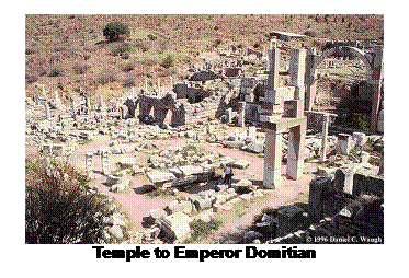
One of its features was a 27-foot-tall statue of Domitian. Along city streets, altars reminded the people of Domitian’s lordship. Once each year, the people had to say publicly, in front of the altar, “Caesar is Lord.” Anyone who didn’t recognize Domitian’s lordship, including no doubt the early Christians, who acknowledge the lordship of Christ alone, were subject to possible death.
If you were to follow the letter carrier from Patmos to Ephesus, you would have docked at the Ephesus harbor. The trip by boat from Patmos to Ephesus is about 60 miles. Who would have been the letter carrier that John used? Most often it would have been a slave who had distinguished themselves as able to be given more freedom. Those who used such servants could request specific ones to work for them. There is a good possibility the apostle John requested the servant he wanted as the courier to take this book to each of the seven churches.
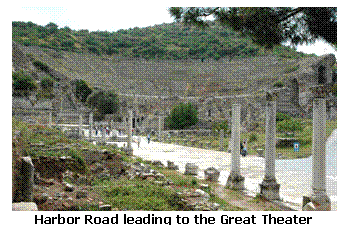
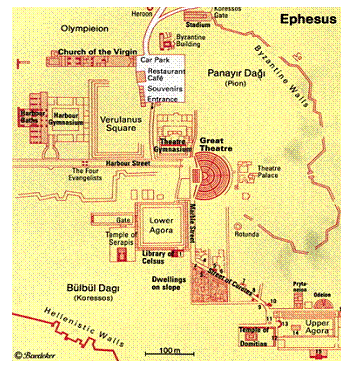
We arrive at the harbor, and after disembarking, we would enter the city using the Harbor Road. As you walk the Harbor Road, the huge theater at its end catches the eyes of any traveler with Mount Pion rising behind it. It might not look like it in this Photo, but the total distance across the front of this theater is nearly 450 feet.
Take a look at the pavement of Harbor Road in the photo. Unlike American roads that break down after 10 years, with some repair, the Ephesian road could still be used today. We like to think of Benjamin Franklin as inventing streetlights. However, 1700 years before he was born, the clever Ephesians had lighted streets. Ships that came in late at night could unload their cargo and bring it into the city by the bright lights that lined the road. This street was almost 100 feet wide, running from the harbor to the theater.
I should mentioned that if you want to do some extra study of the city of Ephesus, you will find some documents and maps calling this street “Arcadian Way.” It would not have been called Arcadian Way during the apostles’ time. Flavius Arcadius was the Roman emperor from 395 to 408 A.D. After his reign, this street took his name.
The theater at the end of this road is one of the largest outdoor theaters in the world. It would hold nearly 25,000 people. Not only could their streets be used today, this theater has lasted for over 2000 years. The Seattle Kingdome did not last 25 years, and at this time, I believe we are still paying for it.
Let me share with you an interesting piece of information. Dr. Joe Fuiten, along with our own Dr. Braddy, were the leaders on our earlier visit to Turkey and Greece. After returning from the trip, I asked Dr. Fuiten for a copy of his book, “The Revenge of Ephesus.” I drove up to Bothell to get the book, and Dr. Fuiten’s secretary, Sheila Shipley, found a draft copy for me. On page 11, I quote Dr. Fuiten:
 “It (the theater) is still in use today for some events. Sheila Shipley, my secretary, graduated from High School in a ceremony held in that theatre.”
When Paul arrived in Ephesus for the first time, some 40 years earlier, he would have come by ship and docked at the same harbor as the letter carrier dispatched by the apostle John. The gospel came to the city at the time of Paul’s second missionary journey. This would make it probably AD 52. He arrives in Ephesus by boat from Corinth, and accompanying Him on this ship were Aquila and his wife Priscilla, whom he had met in Corinth. Two years earlier, Emperor Claudius had expelled all Jews from the city of Rome. Aquila was a Jew, but his wife was not. On this trip, Paul is not long in Ephesus. The Scriptures tell us, in Acts 18:18 that Paul heads for Syria. That most likely means the city of Antioch. Paul began and ended his first two journeys at Antioch. He also begins his third journey from there. When Paul leaves Ephesus, he promised to return, if it be God’s will (Acts 18:24-28). He does return, during his third journey, and stays for three years. Most likely, many churches were begun in Asia during the time Paul was in Ephesus.
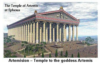
 One thing that would have drawn tourists to Ephesus during the time of the apostles was the Temple of Artemis. To the Romans, Artemis is Diana. The King James and NKJ Bibles read “Diana” while most of the others, like the NIV, read “Artemis.” This temple is mentioned 5 times in the Bible, all in Acts 19.
During its existence, it was the largest building in the world, except for the Great Pyramid and was identified as one of the seven wonders of the ancient world. This temple, called the Artemision, was 425 feet long, 220 feet wide and 60 feet high. It was more than 4 times the size of the Parthenon in Athens. There were 127 marble pillars, a number of them being overlaid with gold and many jewels. Many of the pillars were gifts given by the rulers of many countries. It is believed that in the center of this temple was a huge statue of the goddess Artemis.
 The temple was originally built in about 800 BC. It was damaged on several occasions, but was rebuilt. The temple that stood there when Paul and John were in the city was built some 300 years BC. On the night of July 21, 356 BC, a man named Herostratus burned the temple to the ground. He was trying to immortalize his name, which he did indeed. Oddly enough, Alexander the Great was born on that very night. Just about 30 years later, when Alexander conquered Asia, he offered to rebuild the Temple of Artemis. The temple was rebuilt shortly after Alexander’s death in 323 BC. Above is a picture of the ruins of the temple today, having only one partly reconstructed column standing.
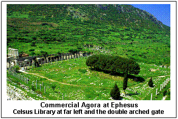
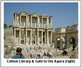
Visit one more place with me. As you walk up Harbor Road from the harbor to the theater, on the right side you would find the commercial agora – the marketplace. It also has biblical significance, for it was in this Agora that Paul, along with Aquila and his wife Priscilla, would most likely have practiced their common trade. What trade did these three share? They were all tentmakers. Paul meets Aquila and Priscilla in Corinth. While Paul preached the gospel, he also made his own living.
 Acts 20:33-34 NKJV
33 I have coveted no one's silver or gold or apparel.
34 Yes, you yourselves know that these hands have provided for my necessities, and for those who were with me.
Paul took no offerings from the people for his ministry. He provided his own finances through his trade. The marketplace was very large, having a length and width that was more than a football field’s length today. The marketplace (agora) was always busy. Farmers from the surrounding area, and craftsmen would sell their wares. Just like today, bartering for the final price was a constant pastime for the shoppers. If you were a bystander at this interplay between seller and buyer, you would observe the devious and clever ways in which the buyer obtains his bargains while, at the same time, the seller would be happy at the final sale price.
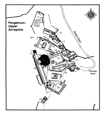
Pergamum (Day 11)
 Google-Earth Coordinates for the acropolis: 39° 07' 57" N 27° 11' 01" E
Google-Earth Coordinates for the Aesclepion: 39° 07' 08" N 27° 09' 56" E
Google-Earth Coordinates for the Serapeum 39° 07' 19" N 27° 11' 00" E
Today we leave Kuşadasi and the ruins of Ephesus, driving nearly 100 miles north to the ancient city of Pergamum, the location of the third of seven churches of Asia Minor as mentioned in Revelation.
The city of Pergamum still exists under the Turkish name of Bergama – population of 55,000. The city has 15 mosques…two churches…and one synagogue, and approximately 25% of the residents profess to be Christians.
If you use a King James, New King James or Living Bible, you will notice this city called Pergamos. All others that I have say Pergamum. Pergamum is the neuter form of Pergamos, the feminine form of the name of the city. Both names were used, but Pergamum was the more common.
The city of Pergamum is located almost 50 miles north of Smyrna. Unlike Ephesus and Smyrna, Pergamum was not a seaport, but located about 15 miles from the Aegean Sea. It was not the city of trade that Ephesus and Smyrna were, but it was definitely the cultural center of Asia, and was its capital for more than 400 years.
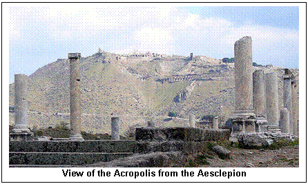
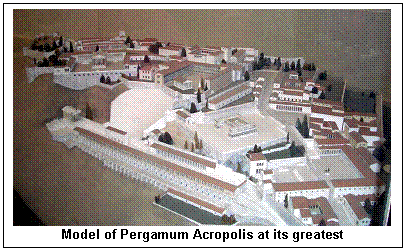
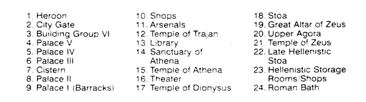
Similar to Ephesus, Pergamum has extensive ruins, over a wide area. Next to Ephesus, Pergamum is the best preserved archeologically. The ruins at Pergamum are in two parts – almost two cities. The one – the acropolis – looking down over the city, and the other in the valley looking up to the acropolis, which is1,000 feet higher.
 There appears to have been a small settlement in antiquity, but little is known of its history. By the 5th century before Christ, coins were issued. The city became prominent in the Hellenistic Period. Lysimachus, one of the four successors to Alexander the Great, deposited 9,000 talents of gold for war expenses with a regional general named Philetaerus. But when the news came of the death of Lysimachus in 282 B.C., Philetaerus used the 9,000 talents to set up his own kingdom, calling it the Attalid Kingdom (named after the nephew of Philetaerus). The successive dynasty was as follows:
Philetaerus (282-241 B.C.)
Eumenes – nephew of Philetaerus (263-241 B.C.)
Attalus I (241-197 B.C.) He held the kingdom against the attacking Galatians. He took the title saviour as the protector against barbarians. He expanded the kingdom along the Aegean and inland.
Eumenes II – (197-159 B.C.) This king was most responsible for building the majority of the Pergamum city seen today.
 Attalus II – (159-138 B.C.) He was the brother of Eumenes II.
Attalus III – (138-133 B.C.) In 133 B.C., Attalus III died, but before He did, he willed his dominions into the possession of Rome.
Attalus III was a shrewd king, and saw the beginning of the rise of the Roman Empire, and, seeing other cities and kingdoms being taken over and sometimes destroyed, he thought it better to give his kingdom to Rome rather than chance destruction. Out of the kingdom of Attalus, Rome formed the province of Asia, and Pergamum still remained its Roman capital.
 The position granted by Rome to Pergamum made it different than every other city in Asia. Rome granted both Ephesus and Pergamum to be a “free city.” That meant they could elect their own governors and statesmen. But Pergamum was granted an additional very significant privilege. Not only were they a “free city” with the ability to choose their own leaders, but they were also granted what in Greek is called “ius gladii” – the right of the sword. The provincial governor in Pergamum could, on his own decision, make the decisions of capital punishment. He had the power of life and death. On his word, a person could be executed on the spot. In Roman estimation, the sword was the symbol of the highest order of official authority. At any moment, this “right of the sword” could be used against any Christian.
When Christ, through the apostle John, described Himself as the One who has the two-edged sword, the Christians at Pergamum knew exactly what that meant. Christ is telling them that it is He, and He alone, who has absolute authority. He has a greater power of life and death. His authority far surpasses the authority of any local or regional governor or king.
Matthew 10:28 (NKJV) tells us:
28 And do not fear those who kill the body but cannot kill the soul. But rather fear Him who is able to destroy both soul and body in hell.
Christ was telling them that even though they may face execution for being a Christian, the real power of life and death belongs to Him. He is reminding the Christians at Pergamum that the last word is still with Him. The power of Rome may be Satanically powerful, but the power of the Risen Lord is greater yet.
Altar of Zeus
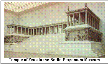 On your visit you will see where the Altar of Zeus was located. This structure is one of four dedicated to a Greek deity. The altar was about 40 feet high and 90 feet square and was constructed by Eumenes II (197-159 BC), after the death of Attalus II as a memorial of the victory against the Galatians. This altar was the largest and most famous in the world at that time.
Many of the great artifacts of Pergamum were taken to Berlin in the late 19th century. A German engineer, Karl Humann, discovered the ruins of the altar in 1871, and had its pieces removed and taken to Berlin where there is a Pergamum Museum. The picture at right is of the front of this altar as it is seen in the Pergamum Museum in Berlin.
In Revelation 2:13, Christ tells the people in this church at Pergamum: “I know where you live – where Satan has his throne.” Could it possibly have reference to this altar to Zeus?
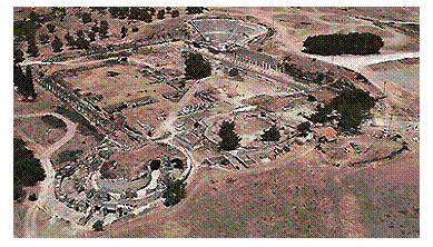 The Aesclepion
Pergamum was noted for their medical center – called the Aesclepion (there are several variation on its spelling), after the Greek god, Aesclepius – the god of healing. Its location is in the valley among the city residents, and this city was dedicated to this god. Many of their coins had his depiction on them. Many Pergamene coins were also struck with serpent encircling a rod, very much like the symbol of the medical profession to this day.
At the Aesclepion, various treatments and procedures were given, some of them very experimental. One section of this medical center was for psychological needs. Hot and cold baths were available. There were different water cures for psychological patients. There is a theater where drama is used as part of the healing process.
Patients would at times be sent through a long tunnel as they contemplated their illnesses. The doctors would secretly observe their patients through openings above, sometimes speaking encouraging words as they walked.
Assos (Modern Behramkale) (Day 11)
 Google-Earth Coordinates for the acropolis: 39° 29' 26" N 26° 20' 13" E
Google-Earth Coordinates for the harbor: 39° 29' 10" N 26° 20' 24" E
From Pergamum to Assos is a distance of 112 miles. Because some of the roads to get there are not highways, it will take us about 3 hours to arrive.
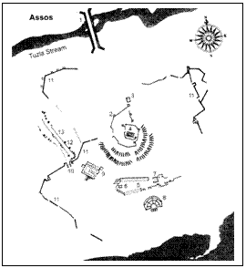
Assos was originally founded in the 7th century B.C. by Aeolian colonists from Mitylene, a city on Lesbos Island, and mentioned in Acts 20:14. In the 6th century it came under the rule of the Lydians, and with their defeat at the hands of the Persians in 546 B.C., the city came under Persian rule. Some of the prominent Persian governors of the region were Ariobarzanes, Euboulos, and Hermias.
In ancient times Assos was a well-known teaching center. Hermias, who was a student of Plato, invited Aristotle, another student of Plato, to live in Assos. He spent 3 years (348 – 345 B.C.) here and married the niece of Hermias and founded a school of philosophy and conducted his early exploratory work in zoology, biology and botany.
Alexander the Great invaded the city in 334 B.C. and later it was attached to the Pergamum kingdom (241 – 133 B.C.). In 331 B.C., the philosopher Cleanthes was born here, and it has been suggested that Paul’s statement in Acts 17:28 (“as even some of your own poets have said, ‘For we are indeed his offspring’”) is a quote from Cleanthes.
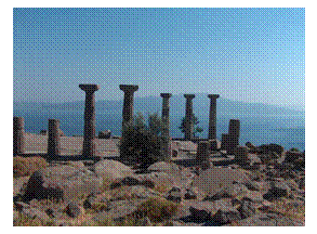 Once we arrive in Behramkale, we will climb the north slope of the 775 foot high acropolis, which will take us about 10-15 minutes. Many of the local people will have their wares for sale along the way. Once you arrive, the main structure at the top is the Temple to Athena, built about 530 B.C. At present only a few of the temple’s columns are standing but restoration work is in progress.
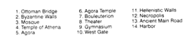 The south slope of the acropolis is the steepest, but it affords a beautiful view of the Aegean Sea and Lesbos Island. The ancient city was built on a number of terraces that circled the mountain. As you look down the slopes to the south and southwest, you will see what is left of a number of ancient edifices – the theater, the agora and the gymnasium. You will also see the modern harbor, which is close to where the ancient harbor was located.
Biblical Significance
On his third missionary journey, and after Paul leaves Ephesus, he goes into Greece for three months. Then, with the intention of going back to Jerusalem, he goes through Macedonia and Philippi, then by boat to Troas, where he stays for seven day (Acts 20:6).
From Troas, Paul and his group go the Assos, but while the rest take a boat, Paul walks the 20 miles (Acts 20:13). He meets his companions at Assos, and from where they sail to Mitylene on their way to Jerusalem.
Çanakkale (Day 11)
 Google-Earth Coordinates for the city: 40° 08' 49"N 26° 24' 30"E
Google-Earth Coordinates for the Akol Hotel: 40° 09' 08.36"N 26° 24' 25.57" E
We travel the 49 miles from Assos to Çanakkale, where we will spend one night. Our hotel – the Akol – overlooks the Dardanelles.
Istanbul (Day 12)
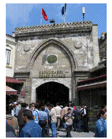
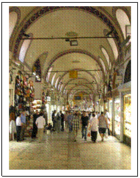
 Google-Earth Coordinates for the city: 41° 00' 45" N
28° 58' 32" E
Coordinates for the Germir Palas Hotel: 41° 02' 20.49" N
28° 59' 07.61" E
Coordinates for the Grand Bazaar: 41° 00' 38.09"N 28° 58' 04.56"E
On our last day we will visit the Grand Bazaar, the largest covered market in the world. If you like to shop, this market will probably have what you are looking for. It contains 4,400 shops, 64 streets, 25,000 employees, 2 fountains, 33 gates and two mosques. It is well known for its jewelry, pottery, spice, and carpet shops. Many of the shops in the bazaar are grouped by type of goods, with special areas for leather coats, gold jewelry and the like.
The market began during the 15th century, by order of the Sultan, Mehmed the Conqueror. It was greatly enlarged during the 16th century during the reign of Sultan Suleiman the Magnificent. In 1894, it underwent a major restoration following an earthquake. The Bazaar has between 250,000 and 400,000 visitors each day.
